Understanding earth subsurface with high confidence
The Norwegian offshore offers a multitude of possibilities for CO2 storage. But to unlock this potential and minimize the risks associated with storage, a good understanding of the subsurface is essential. Major partner of Eliis for many years, ExploCrowd has created the RE:initiative consortium to help industry assess the properties, sealing capabilities, pressure, temperature and injectable CO2 quantity of reservoirs on the Norwegian continental shelf. They currently have a collaboration with Stella Maris. Their role is to identify CO2 storage sites in the Norwegian North Sea that best meet the strategic requirements of the project.
Sidsel Lindsø, ExploCrowd's founder and geologist-explorer, and Gustavo Lopes, senior geologist, kindly agreed to answer some questions to help us understand better how geologists work with CO2 storage.
What are the geological characteristics of a good offshore CO2 storage site?
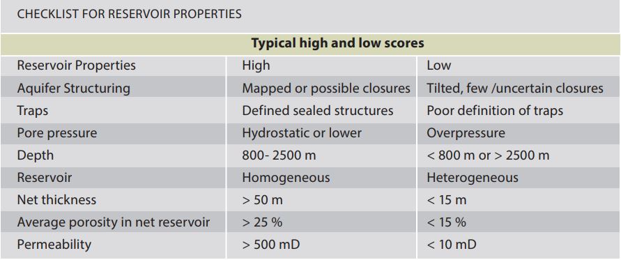
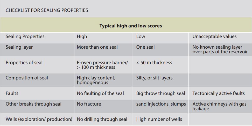
We follow the methodology suggested on the
atlas published by the Norwegian Petroleum Directorate (NPD). The main characteristics are summarized in the two tables below. Our expectation is that some flexibility is required as these standards are quite high. In a simplified version, we try to find a structure that is constrained and well-defined in seismic data within the depth limits set by the NPD, and at the same time is in open contact with a potentially important aquifer. Ideally, there is a reliable well data point nearby that can be connected to help us define a good combination of reservoir properties and sealing potential, with high confidence in both presence and quality.
CO2 storage Atlas Norwegian North Sea, Norwegian Petroleum Directorate
What are the main differences between a CO2 storage in an old, depleted reservoir and in an intact reservoir? Is the risk more limited in unaltered reservoirs? What are the pros and cons to go for a brand new virgin reservoir?
An old reservoir typically will have many abandoned wells that can be potentially problematic regarding leakage past the top seal. Additionally, oil and gas reservoirs can be produced even if there is not much connection to a large aquifer, but that creates considerable limitations for how much CO2 can be stored. On the positive side, in an old reservoir we will probably have a very good understanding of the reservoir properties and dynamics. These will have a much higher risk when we are evaluating a new reservoir. What is also an important aspect is that steel corrodes when exposed to CO2 , and that can cause significant problems for the existing wells in the old gas field that should now be used for injection. Hence, new virgin reservoirs can be considered lower risk than repurposing old gas fields.
What tools do you use to locate them? What is your approach?
For the screening study for Stella Maris project, we have used DUG Insight and
PaleoScan™ for seismic visualization and interpretation. The integration between these softwares increases our speed and confidence in identifying geometries and geomorphologies deep in the ground. We have used seismic data and well data from the NPD hosted DISKOS Database, and we have integrated insights from relevant publications. So it is pretty much the same workflow for screening a hydrocarbon reservoir for where it is possible to find oil and gas accumulations.
How does PaleoScan™ help you in your work?
PaleoScan™ increases our speed when interpreting seismic cubes in providing us with a full interpreted volume on each seismic event. That, in combination with the attributes and color blends, and especially Spectral Decomposition, allows us to quickly get a structural understanding and reveal geomorphologies that with the conventional interpretation would be hidden. Using PaleoScan
™, we have set up a workflow that can screen full seismic volumes in large areas, extremely fast.
What risks related to CO2 storage does your expertise and your approach contribute to reducing?
The most important risk is that the CO2 could leak from the trap, and that cannot happen. Hence, we work hard to make sure that the risk is kept to a minimum. The identified geomorphologies help us narrow down reservoirs and seal properties and attributes on horizon stacks help us define potential lateral heterogeneities. Detailed structural evaluation defines the trap, potential flow barriers, connection to aquifer and potential fault seal properties. Geopressure evaluations and all information above are then included in dynamic models where we simulate injection of CO2 over many years, and thereby we get a better understanding of how the reservoir behaves when you inject many tons of CO2. This also helps us to understand how much it is possible to inject over time, and that helps the clients to define the best balance between infrastructure needed to maximize volumes injected in time and optimize the business case for specific projects.
So our expertise as geoscientists and reservoir engineers is quite essential to all CCS projects, worldwide, actually.
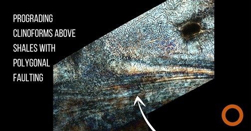
"What to do when you need to understand the lithology of different geological layers kilometers deep in the ground, and you are far away from wells? You can use PaleoScanTM technology to scan through the different layers in the seismic data, wiggle by wiggle, using the Spectral Decomposition attribute. This example covers a couple of seismic wiggles and show polygonal fracture patterns that are characteristic for shale. Above that, prograding from the south, you see the striped bands of sands and silt being deposited in front of a shelf edge, which will later cover the shale entirely. The oval black feature in upper right corner is a salt diapir that has penetrated through the Paleocene section from below, after deposition of the shale and prograding clinoforms.” (Sidsel Lindsø)
Interview by Véronique Molénat