Icon décoration

PaleoScan™ 3D Geocellular Model

PaleoScan™ 3D Geocellular Model

3D Geocellular Models which represent reservoir geology play an important role in the petroleum exploration workflow. Such models are the key inputs for reservoir simulation to predict future reservoir performance, as well as aiding the communication between all disciplines, from geoscientists to reservoir engineers and production engineers.

PaleoScan™ includes an innovative workflow for reservoir modeling which allows the user to build a 3D Geocullar Model in a short time frame with greater accuracy and efficiency compared to conventional techniques.

Thanks to the creation of a 3D Relative Geological Time (RGT) model via the 3D Model Grid method, the geometry of the 3D Geocellular model can be defined more precisely in terms of both stratigraphic sequence and seismic expression. The 3D RGT model provides an unlimited number of 3D chronostratigraphic surfaces, any of which can be used as sequence or lithological boundaries in the Geocellular model. Truncations can also be defined between boundaries, here an upper erosional contact is defined using  PaleoScan™ Truncation capabilities:

Figure 1: Example from Draeck 3D, offshore North West Shelf, Western Australia, (Clio-1 exploration well shown). Left: Stratigraphic Sequences can be defined from the 3D RGT Model; Truncation mode was used to create erosional contact between sequences. Right: the geometry of the 3D Geocellular Grid is updated on the fly, follows the changes in the stratigraphic model.

Layering can also be defined per sequence using the new layering options from PaleoScan™ version 2019. Thus, the user will have control over the number of sequence sublayers (vertical resolution), lateral resolution (grid size) and also the sub-layering styles (isoproportional, parallel top/base), within the 3D Geocellular Grid. More importantly, these parameters can be changed and updated on the fly, drastically reducing the turn around time for testing model geometries and scenarios.

Figure 2: Left: the changes in sub-layering styles (iso-proportional, parallel top/base) and the number of sequence sublayers from the Strati Viewer. Right: the internal geometries of the model are updated on the fly in the GeoCellular Computation interface.
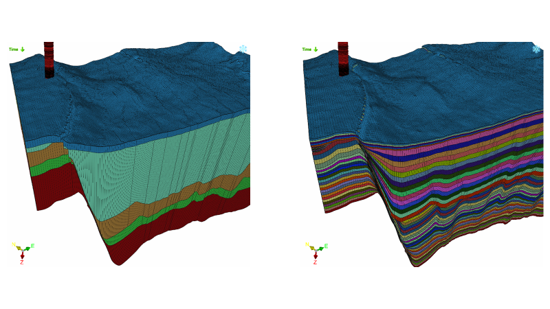
Figure 3: The comparison of the internal geometries between. two 3D Geocellular Models. Left: 3D Geocellular model with only five sub-layers. Right: 3D Geocellular model with a high number of sublayers and different styles of sub-layering

Faults, well logs data and seismic attributes can be integrated into the 3D Geocellular Model, to not only replicate the 3D structure of the reservoir but also the rock and fluid properties assigned to it. The user can export the model in Eclipse Grid File Format (GRDECL).

Figure 4: Example from Maui 3D showing GR values from well logs can be populated in each cell of the grid. The user can easily navigate vertically and laterally to each layer of the 3D Geocellular Model.

To find out more about the 3D Geocellular Model drop us a line.

Case study: Draeck 3D, offshore North West Shelf, Western Australia. Maui 3D, offshore Taranaki basin, New Zealand.

EvènementsShare on social media

Drop us a line !

Stay connected !

Stay connected !